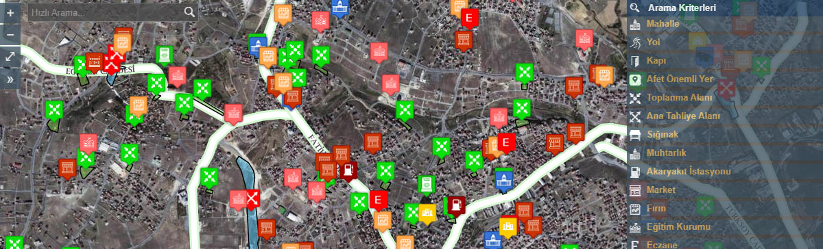
GEOGRAPHIC INFORMATION SYSTEM

Geographic Information System is a computer-based system for mapping and analysing any kind of existing or new data on earth. Geographic Information System uses a technology that combines common database operations such as querying, imaging, statistics, analysing, and geographic analysing of maps.

All these features distinguish Geographic Information Systems from all other information systems and make it a substantial asset for planning strategies, forecasting results, explaining occurrences, responding to general and special operations. This system, which is named as GIS (Geographic Information System) all over the world, is being used effectively in the areas of urban planning, implementation of plans, and geographical monitoring of urban and estates for the development based local administration strategies.

WHAT IS THE ROLE OF MUNICIPALITIES?

The first order of business for any local authority to undertake is the geographical location of a settlement, population, social conditions, availability of industry, tourism, agriculture, and trade etc. as means of living. The municipalities are the institutions that are most suitable for the use of Geographic Information Systems as they closely follow the socio-economic developments, estates and the structuring.
An effective Geographic Information System solution consists components such as powerful so‑ware, seamless and fast restorable hardware, human factor, local data collection and method.

CITY INFORMATION SYSTEM

City Information System is the city-based application of Geographic Information System. This system stores spatial and non-spatial data in a computer with a certain technique, and processes and analyzes the stored information and enables administrations to implement their decisions.

With the City Information System, we provide a fast and beneficial way of reviewing the needed planning, infrastructure, engineering, basic services and management information to make optimal decisions to carry out urban activities smoothly.

We are able to produce sociological and demographical maps of the city, and we offer the opportunity to monitor the development of the city. Additionally, we are able to monitor the city's infrastructure data in graphics via computers and work in tune with the infrastructure services. Thanks to this service the nearest hospital, educational institution, official institutions, historical buildings and areas, religious facilities, health facilities, important business centres, hotels and police stations can be found easily and the information can be printed out effectively.

As Erhan Reklam, we also provide comprehensive inquiry and tracking using both graphical and verbal databases by using the City Information System.

NUMBERING


We start working by making the necessary detections, getting access to the satellite photos, and we update the data after the field trip. We assemble the number plates of all buildings, roads and streets by numbering.

We make use of technology in all the projects that we do. After the field detections, and scrutinizing the map to see whether it is up to date or not, we mark the out-of-date plates through a computer.

Having done the necessary field detections with our experienced crew we list entrances, and entrances with double entry, street-facing sides, and out-of-date numbers of all buildings and office premises. We transfer the data stored on the tablet computer to the central server via the Internet at the end of the day.

We produce and assemble new number plates with the approval of municipal authorities for the completed roads and streets.

ADDRESS INFORMATION SYSTEMS

In order the Address Registration System to be successful, the Numbering and Address Information System work must be whole and complete.

Numbering and Address Information System work include the numbering of addresses on the field, hanging number plates, and processing all the addresses into the National Address System.

As being one of the biggest producers in the field of production and assembly of Address Information Plates, we carry out all these processes smoothly as well as domestic and international projects. We produce and assemble most of the doorplates especially in İstanbul, İzmir, Mersin, and Kocaeli. We are happy to be one of the biggest firms of the sector in Europe and the Middle East thanks to our manufacturing speed and quality.

ADDRESS INFORMATION PLATES

We offer our production and assembly services for Door Number Plates, Wall Plates, Direction Signs, Route Markers and Individual Unit Plates (Doorplates).

RFID SYSTEM

Radio Frequency Identification (RFID) is a technology used to describe beings or objects by radio waves. The reader in the system allows the radio waves from the RFID tag to be converted into digital information and transferred to the computer system.

WHY RFID?

With the help of RFID technology, doorplates are not just plates that show the number of a door anymore. We add an RFID tag onto the plate in accordance with the needs. Our authorized personnel who are on the field can reach the necessary information about the structure with a handheld terminal that can read RFID tags. When the RFID tag is scanned, the signal reaches the computer in the system. Depending on the barcode number entered on the computer, the information in the database about the structure is reflected on the screen. So, the doorplate becomes something more than a door number plate that is just a number sequence, which only symbolizes the position of that building in the street.

LACS INTEGRATION IMPLEMENTATIONS

We eliminate economic losses due to address difference by producing data on the quality and quantity of the current population based on settlements, and ensuring that address and population information are tracked from a  single center.

With this application, we eliminate the additional cost burden of creating and updating electoral roll in census and population detection.

Thus, we ensure that public services are carried out effectively and efficiently, public inspection mechanisms work more efficiently, and that all the organizations can work under a common e-Government structure within the framework of interoperability.

We have applied this project in Tekirdağ Muratlı, Tekirdağ Ergene, Tekirdağ Süleymanpaşa,Balıkesir Metropolitan Municipality and Kütahya Tavşanlı.

DISASTER INFORMATION SYSTEM

Adapting technology to the plates with the Disaster Information System, we show our citizens where they need to congregate at the time of a disaster. We create an identity card for each building. Mobile phones can scan the 2-d barcodes that show the maps for the assembly area.

DISASTER INFORMATION PLATES

We carried out Disaster Information Plates project with Beşiktaş Municipality and İzmir Metropolitan Municipality.

CEMETERY INFORMATION SYSTEM

With the Cemetery Information System, we cater for all kinds of information needs of our citizens visiting the cemeteries. Thanks to this system, our citizens who came to visit the cemetery can easily and comfortably find the place to visit by simply writing their first and last names through the interactive devices at the cemetery entrance.

We provide information about the identity of the deceased, also a cemetery plan, and route information.


CEMETERY INFORMATION PLATES

We manufacture perfectly and assemble the plates to be used in the cemetery.

DATA DETECTION & ANALYSIS

All the data belonging to the settlement areas are collected and matched with the graphical and non-graphical information, the querying and analyses are made in Data Detection Analysis work. We update all buildings, and streets with our latest data detection application including Geographic Information Systems, Urban Information System, Address Information System and National Address Data Update.

The geographical information, construction date, functions, properties, construction quality, fuel type, heating system, home or workplace status of the projects prepared and buildings constructed in accordance with the "Outer Door Numbering Project" applied by İstanbul Metropolitan Municipality, ownership or tenant status, elevators, parking lot and occupancy situation can be easily detected with this application.

In addition to these, the population structure of the county, and population of neighbourhoods, employment structure, day and night population structure, labor force characteristics and sectoral distribution can be determined. All this updated information is archived on the computer and we provide the fastest and the right information to the people of the district with satellite photos.

Thus, citizens needn’t wait for tax and zoning operations, and for address-based procedures in official institutions.

STREET FURNITURE

Urban furniture has an important potential in terms of raising public awareness and educating the public about environmental problems by local governments. For example, an environmentally friendly urban furniture that contains ecological elements or is made with the recycling of waste materials can convey important messages to its users.

  • Seating areas (benches, chairs and many similar areas)
  • Lighting fixtures (street and similar other products)
  • Deterrent and limiting products (such as traffic or pedestrian barriers)
  • Information or traffic signs (signage product types that includes all information on streets)
  • Various types of top cover items (many selections such as bus stops, canopies)
  • Trash cans

MAPPING WITH DRONE

With the recent developments in UAV (Unmanned aerial vehicles) technology, they have started to be used in cartography sector as well as in many other sectors. It produces economical, fast and high-accuracy maps from the air with a drone that has RTK / GPS system developed exclusively for mapping.


ADVANTAGES OF DRONE MAPPING APPLICATION

By connecting an UAV that has the RTK/GPS capability to the CORS-TR System (Turkey National Fixed GNSS Network - Active.), it provides high-accuracy and balanced coordinates that can be obtained in real time which produces Digital Elevation Model (DEM), Base map, Orthophoto and 3D models with the Dense Image Matching method.

ADVANTAGES OF DRONE MAPPING APPLICATION

With Drone Mapping, it is possible to map very large areas in a short time, without sacrificing accuracy, at low cost.
Time
Cost
Accuracy
Precision


1
1

SCOPE OF APPLICATION

• Base Map production
• Orthophoto
• Digital Elevation Model
• Construction projects, mine sites, quarries, dump sites, garbage dumps
• Multispectral Imaging
• Agricultural Productivity Maps
• Measurement of mine sites, quarries, dumps and landfills - volume calculations
• Measurement of industrial zone and facilities
• Measurement of archaeological study areas
• Solar Power Plant mapping
• Measurement and mapping of catchment areas
• Measurement of marshy areas
• Emergency maps of natural disaster areas
• Measurement of urban transformation areas
• Measurement of pasture areas
• 3D city modelling

OUR REFERENCES

1
İstanbul
2
Kocaeli
3
Sakarya
4
Bursa
5
Çanakkale
6
Balıkesir
7
Kütahya
8
Eskişehir
9
Ankara
10
İzmir
11
Aydın
12
Muğla
13
Antalya
14
Mersin
15
Isparta
16
Kırıkkale
17
Kayseri
18
Zonguldak
19
Kastamonu
20
Kahramanmaraş
21
Tokat
22
Ordu
23
Malatya
24
Adıyaman
25
Erzurum
26
Şanlıurfa
27
Trabzon
28
Ardahan
29
Ağrı
30
Van
31
Batman
32
Çorum
33
Elazığ
34
Hatay
35
Sinop
36
Konya
1
Katar
2
Greece
3
Uganda
4
Ethiopia
5
Libya
6
Seychelles
7
Afghanistan
8
Germany
9
Malta
10
Ivory Coast
11
Kazakhistan
12
Azerbaijan
13
Russia
14
Saudi Arabia